TAC Sponsor Spotlight Article – Arcadis
By Zoltan Mucsi, P.Eng., Intermediate Transportation Planner, Arcadis
This article is a sequel to an article titled Shaping Ottawa’s Transportation Future published on the TAC website on December 7, 2023.
What is the TMP?
The Transportation Master Plan is the City of Ottawa’s blueprint for planning, developing, and operating its walking, cycling, transit, and vehicular networks in the decades to come. Guided by Ottawa’s Official Plan, which sets the policies and goals surrounding the city’s development, the TMP identifies transportation policies and projects to meet the needs of residents and businesses from now until 2046. The TMP builds on previous plans completed in 2003, 2008, and 2013, and was developed based on extensive stakeholder and public feedback.
Through the Official Plan, the City has set a goal of becoming North America’s most liveable mid-sized city and has developed five “Big Moves” related to growth, mobility, health and resiliency, urban design, and the economy—each providing strategic direction to achieve this broader vision. The TMP supports the mobility objectives of the Official Plan with an emphasis on supporting growth and intensification, enabling complete and healthy communities, providing transit at the outset of new community development, advancing climate mitigation and adaptation measures, and building a safe and equitable transportation system.
The TMP was developed in two parts: a policy framework and a capital infrastructure plan. Arcadis was retained by the City to help prepare this strategic plan.
Part 1: Policies
The first part of the TMP was approved in April 2023 and established a policy framework for improving Ottawa’s transportation system across all modes. Specific objectives guiding the development of the TMP include the following:
- Encourage the use of transit and active modes to reduce pressure on roads, mitigate greenhouse gas emissions (GHG), and use space efficiently;
- Implement cost-effective transit infrastructure projects where there is the greatest potential to attract new riders and improve service for existing riders;
- Pursue road capacity projects that provide access to development and address congestion bottlenecks;
- Invest in “complete streets” that accommodate all modes of travel, to support growth and intensification; and
- Maintain a strong affordability
Part 2: Capital Infrastructure Plan
Part 2 of the TMP was approved in July 2025. The Capital Infrastructure Plan identifies the transit, road, and active transportation projects and investments that are required to support Ottawa’s projected growth and achieve the City’s objectives for a flexible, dependable, safe, and efficient transportation system. It also identifies a subset of the most essential and cost-effective priority projects that are expected to be implemented by 2046, given funding and affordability constraints.
Changing Travel Patterns
Ottawa has seen many changes over the past decade, including the construction and opening of the O-Train, significant investments in walking and cycling infrastructure, and the COVID-19 pandemic. The city has also grown substantially in population and experienced changes in work and travel patterns. The 2022 origin-destination (OD) household travel survey results indicate significant changes in travel patterns, including:
More people working from home – The COVID-19 pandemic caused significant disruptions to travel, with implications that are likely to be long-lasting. In particular, there has been a dramatic increase in working from home. In the Fall of 2022, 19% of Ottawa workers were still fully working from home, with 35% having hybrid work arrangements and commuting on average 1.6 days a week.
Fewer and shorter trips – With the increase in working from home, the number of daily trips per person decreased from 2.76 to 2.50 between 2011 and 2022. Overall, the total daily trips starting or ending in Ottawa decreased by 0.7% over this period, despite significant population growth. This is a notable departure from the historical trend of trips increasing with population.
Fewer people travelling downtown – Compared to 2011, daily trips to the downtown core decreased dramatically due to a reduction in work trips, while trips for other purposes remained relatively stable. Overall, daily commuting trips to the downtown core from the suburban areas decreased by over 51% between 2011 and 2022. Daily commuting trips by transit from these areas dropped by almost 70%.
More “internal” trips within the suburbs – Trips made in the suburban areas were also more localized, showing an increase in “internal trips” starting and ending in the same community. This suggests that these areas increasingly operate as complete communities with many services and amenities.
The 2022 OD survey captured travel patterns at a moment in time when the region was still transitioning from the pandemic. Since then, travel behavior has continued to evolve. Recent data shows a gradual recovery of peak period travel volumes, with increases in both transit ridership and driving trips.
Additionally, Ottawa, like most cities, is facing a climate emergency and ongoing uncertainty about post-pandemic lifestyles and travel patterns. Affordability pressures continue to grow, and there is an increasing need to enhance public health, safety, accessibility, and equity. As the city continues to grow and intensify, the question is: how can Ottawa’s mobility system be planned, developed, and operated to meet the needs of the City from today to 2046?
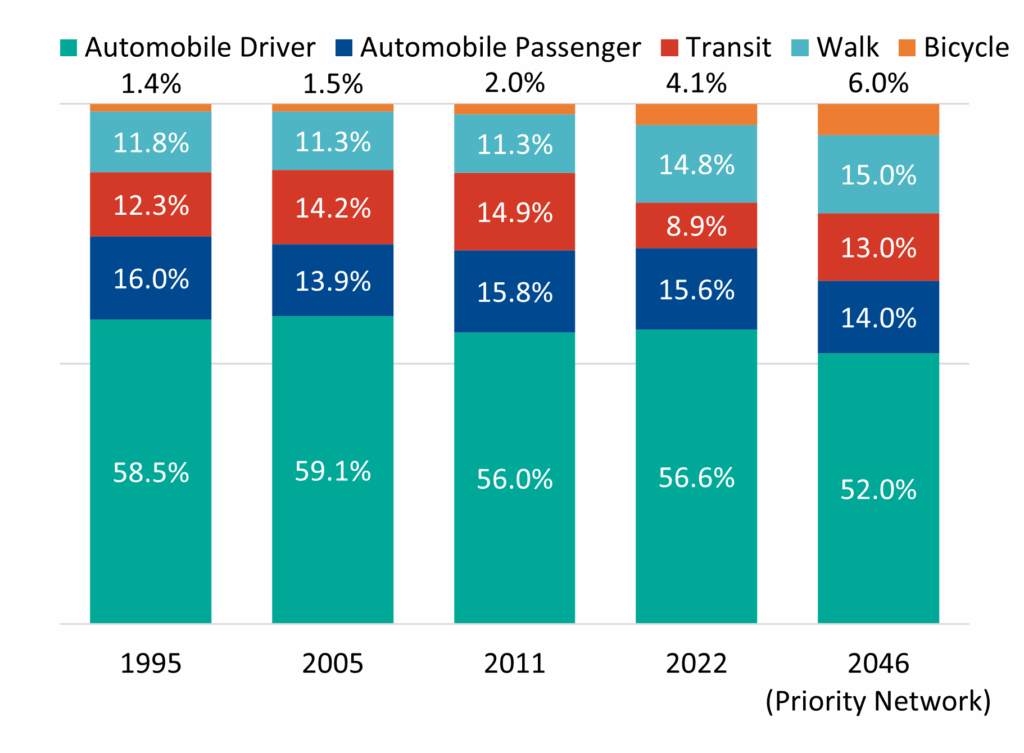
Weekday Mode Share Over Time (1995–2046)
Future Conditions
Travel outlooks to 2046: Ottawa’s population is expected to reach 1.4 million by 2046, growing by approximately 300,000 people from 2021. The distribution of this population growth has a major impact on future travel demand. The Official Plan calls for 47% of the city’s new dwellings to be built within the existing built-up area (mainly inside the Greenbelt), 46% to be built in suburban greenfield areas (outside the Greenbelt), and 7% to be constructed in Ottawa’s rural villages and surrounding lands.
The technical analysis to support the development of the Capital Infrastructure Plan involved forecasting a “business-as-planned” scenario. This scenario shows how the city’s future population is expected to use the transportation system in 2046, assuming no additional investments or changes other than projects which are currently under construction, or for which funding has been committed.
Analysis of the business-as-planned scenario found that Ottawa’s current growth and travel trends will lead to changes that include new demand for 1.25 million more daily trips, including upwards of 630,000 driving trips. This reflects a total trip increase of almost 52%, outpacing both population (34%) and employment growth (25%). Other changes include more trips from suburban and outer urban communities, an increase in congestion for peak period automobile trips, and an increasing share of transit trips.
Developing Networks
Candidate projects were compiled from existing plans and studies, internal and external stakeholders, public consultation, and needs and opportunities analysis. Candidate projects were assessed through modelling and analysis. Those that met mobility needs to 2046, were technically feasible, and aligned with transportation policies, were carried forward. This analysis of projects resulted in the “Needs-Based Networks” of transit and road projects. A “transit-first” approach was taken to meet 2046 travel needs and develop the Transit Needs-Based Network. The residual auto demand (i.e. the demand that is not expected to use transit) formed the basis for assessing road capacity needs and established the Roads Needs-Based Network.
The Council-approved Transit and Road Project Prioritization Framework was used to score and rank projects for implementation. Prioritization for transit projects assessed ridership growth and service improvement. Prioritization for road projects assessed mobility needs like access to development and congestion reduction. For both transit and road projects, city-building considerations were assessed, including impacts to equity and natural systems, access to major destinations, economic development, and GHG emissions. Capital cost estimates were also assessed.
Project Prioritization Frameworks

Outcomes
The network development process resulted in multiple investment scenarios and networks. These include city-wide transit projects to make transit more reliable and attractive, and road projects to provide access to new development and manage congestion bottlenecks in key locations. Pedestrian and cycling facilities will be incorporated as appropriate in all transit and road projects, as per the City’s Complete Streets Policy.
The identification of key transit and road projects resulted in the “Priority Networks” of transit and road projects. The priority networks will increase sustainable mode share, improve transit travel times, improve access to jobs and amenities, and encourage transit-oriented development city-wide, compared to the business-as-planned scenario.
Taking a Closer Look at the Transit Priority Network
The Priority Transit Network identifies key projects that are expected to attract new riders and accommodate growth by improving travel speed and reliability on existing high-ridership urban corridors and connecting suburban communities to the core O-Train and Transitway networks. Project limits and facility types were identified to maximize cost-effectiveness and enable implementation of improvements city-wide.
Transit Priority Network Map