Our roadway network connects our communities, provides vital access to services, and moves goods and people to support our economy. Built with long lifecycles, our roads and bridges offer safe passage for travelers in a variety of weather conditions.
Extreme weather events, such as heavy rainfalls that cause floods and debris flows, threaten our infrastructure’s longevity and vitality, and cut off critical access to goods and services. With climate change increasing the frequency of these weather events, we need to better understand, prepare for, and mitigate the fallout from floods and landslides quickly and efficiently.
With Stantec’s DebrisFlow Predictor and Flood Predictor, you can.
Oftentimes, roads traversing through mountainous terrain are the only through route for miles. Landslides across these routes cut off access between communities, leaving citizens and travelers stranded. Understanding the behavior of extremely rapid, shallow, flow-type landslides—such as debris flows and debris avalanches—can help predict these events, allowing agencies to mitigate landslides before they happen.
Traditionally, physical stations are used to collect data on storms and landslides. However, these stations do not comprise a dense network. On average, Canada has one physical station for every 5,000 km, leading to gaps in the data where there are no stations.
DebrisFlow Predictor, a stand-alone two-dimensional agent-based landslide simulation model, deploys 5 m x 5 m agents (autonomous sub-routines) over a digital elevation model of the same resolution. Each agent acts on a set of rules that describe its ability to scour, deposit, move, create, and interact with other agents. The rules are physically and empirically based and together, produce results that are characteristic of debris flow behavior. DebrisFlow Predictor is easily calibrated to account for local conditions. By modeling hundreds, thousands, or tens of thousands of debris flows, the modeler can identify sections of highway that are most vulnerable to landslide runout.
DebrisFlow Predictor shows landslide paths, inundation, scour, and deposition in every 5 m grid cell downslope of an initiation point. Correctly calibrated, the results predict the characteristic behavior of debris flows that may occur. Using multiple runs, the software also provides data that can be used to determine the likelihood that any particular grid cell will be subject to a hazard initiated from upslope.
DebrisFlow Predictor tells expert users whether any receptor (e.g. a road or rail line) or location in the landscape could be impacted by a debris flow. It helps quantify the likelihood and the impact of such an event. Combined with other Stantec innovations (Scenario Creator, Slope Manager) users can also predict the likelihood that such a hazard will occur, and actively monitor the background conditions and warn end-users when they are at risk from upslope hazards, and the extent to which they are at risk.
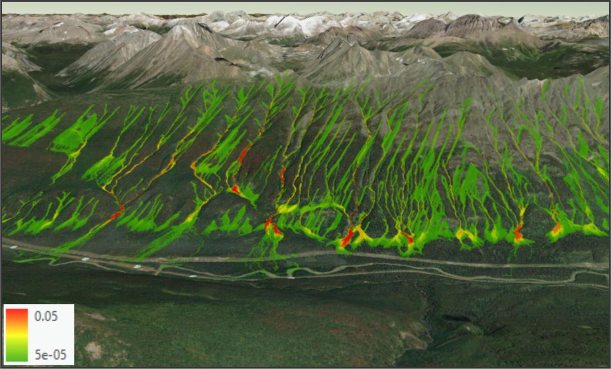 |
| Figure 1. Modeling thousands of landslides and correcting for the observed landslide occurrence allows the user to provide quantitative hazard scores for areas where there is a hazard-highway interaction. |
Like landslides in mountainous terrain, flooding is just as devastating. The economic and societal impacts can devastate communities for years. Trying to predict these events can be complicated, complex, and time-consuming. Flood Predictor provides an easier way.
Flood Predictor is a secure, cloud-based solution that provides insights on when and where a flooding event is likely to happen. It is powered by data and engineering features, creating a first-of-its-kind methodology that can analyze flood hazards, project future climate scenarios, incorporate local adaptation, and validate against government records.
Regional flood analysis depends on efficiency, and traditional methods have not historically delivered this. Complicated by hydrology and hydraulic complexity, these models take hundreds, even thousands, of hours to produce—and for a hefty price tag. Flood Predictor changes the game, using machine learning to provide accurate results in mere seconds.
Flood Predictor provides near real-time flood hazard data that is correlated to detailed 2D hydraulic modeling. Inundation areas can be developed based on current weather conditions or hypothetical storm events, expanding risk data availability for all transportation infrastructure assets, even in areas not previously modeled or mapped. The cloud platform also provides scalability so that regional scale results can be developed at high resolution.
With Flood Predictor, we’re helping clients quickly achieve between 85% and 95% hydrology and hydraulics model correlation, creating a strong foundation for professional science and engineering services. Flood Predictor provides insights on when and where a flooding event is likely to happen, based on data, statistical simulation, and sound engineering, to help you optimize decision making.
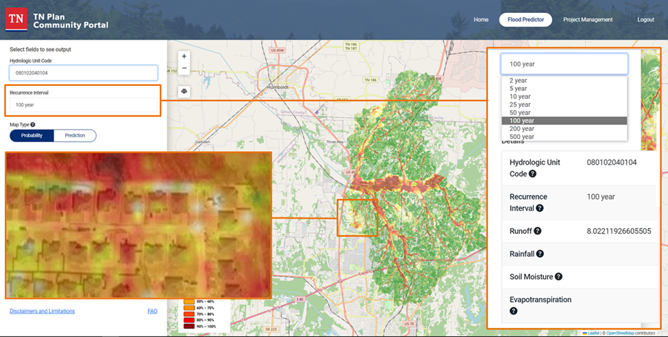 |
| Figure 2. Flood Predictor Platform showing hazards for hypothetical storm events. |
To learn more about Stantec’s Predictor Tools, please visit:
Thank you to our Premier Sponsors
 |
 |

